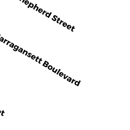
69 SHEPHERD ST
Owner Information
RYAN KAITLIN D
69 SHEPHERD ST
CHICOPEE, MA 01013 2031


Property Details
69 SHEPHERD ST is classified as a Two-Family Residential (Two family).
The primary structure on this property was built in 1900. There are 3,893ft2 of built area within this property. There is 2,219ft2 of residential/living space within this property. This property is listed as having 10 rooms.
69 SHEPHERD ST is valued at $219,900. The land is valued at $78,700 and the structures are valued at $141,200.
The most recent deed for 69 SHEPHERD ST is recorded at the local registrar in Book 21868, Page 136. 69 SHEPHERD ST was last sold on Thursday, September 21, 2017 for $178,900.
Assessment data from fiscal year 2022.
Flood Data
According to the FEMA National Flood Hazard Layer, this property does not appear to be in a flood zone. It may also be in an area not yet reviewed. Nonetheless, confirm this information prior to taking any action.
To view the flood hazards around this property, create a FEMA "Firmette" Map of the area around 69 SHEPHERD ST.
Broadband Internet Providers
| Provider | Type | Bandwidth (mbps) | |
|---|---|---|---|
| Charter Communications Inc | Cable | 940 | 35 |
| VSAT Systems, LLC. | Satellite | 2 | 1 |
| HughesNet | Satellite | 25 | 3 |
| GCI Communication Corp. | Satellite | 0 | 0 |
| Verizon New England Inc. | DSL | 7 | 0 |
| Viasat Inc | Satellite | 100 | 3 |
Broadband service provider data from December 2020.
Adjacent Properties
- 79 SHEPHERD ST
Single Family Residential owned by ROUX JOHN D - 200 NARRAGANSETT BLVD
Single Family Residential owned by WATERFALL VICTORIA GRANTOR TRUST II - 198 NARRAGANSETT BLVD
Two-Family Residential owned by RODRIGUEZ RODOLFO & - 192 NARRAGANSETT BLVD
Two-Family Residential owned by ZUKOWSKI CHRISTOPHER P - 61 SHEPHERD ST
Single Family Residential owned by MOQUIN SHERRI